
- Thank you received: 0
T or E
19 years 9 months ago #15958
by rderosa
Replied by rderosa on topic Reply from Richard DeRosa
<blockquote id="quote"><font size="2" face="Verdana, Arial, Helvetica" id="quote">quote:<hr height="1" noshade id="quote"><i>Originally posted by neilderosa</i>
<br />Here's my amateurish composite of the T or E taken from Public Request images posted recently, and a small part of the original SP24 "T."<hr height="1" noshade id="quote"></blockquote id="quote"></font id="quote">
Hmmm. Very interesting. I wonder.
Yes, I noticed that little round area, also. Very curious.
Although, blowing them up reaks havoc with the LIE, unfortunately.
rd
Please Log in or Create an account to join the conversation.
- neilderosa
-
- Offline
- Platinum Member
-

Less
More
- Thank you received: 0
19 years 9 months ago #9000
by neilderosa
Replied by neilderosa on topic Reply from Neil DeRosa
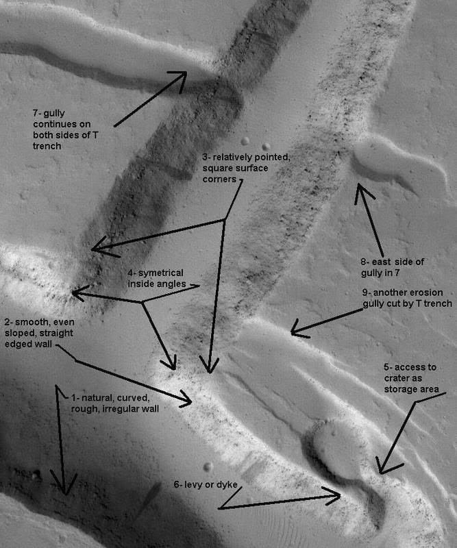
<blockquote id="quote"><font size="2" face="Verdana, Arial, Helvetica" id="quote">quote:<hr height="1" noshade id="quote">It is here hypothesized that a natural trench made perhaps by a meteor gouging out a length of the Martian plain, was used by intelligent beings as a starting point for the subsequent cut-out which produced the T. Evidence is as follows:
1- The upper part (upright part of T) forms an almost perfect 90° angle to the natural trench.
2- The inner angles are cleanly cut and sloped downward on both sides of the trench with straight walls and a straight surface cut on both sides.
3- The “base” of the T (uppermost end of T in image) appears to be cut out in the shape of a diamond or oval with flat ledges, giving it a distinctively artificial look.
4- The upright part of the T is narrow at the base and widens in an even pattern until it meets the T-cross part, at which point are the two symmetrical inside corners.
5- The surface cut of this part of the T is a neat “machine cut” presumably unchanged since its construction due to minimal Martian erosion.
6- Dimensions and analysis of shape to follow further reinforce this hypothesis. [T or E paper MRB, 6/15/06]
<hr height="1" noshade id="quote"></blockquote id="quote"></font id="quote">
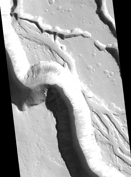
That was written around a year ago. I would now add to "natural meteor gouge-out" above, “exposed lava tube,” or “possible water erosion.” There are several similar formations in the area of the T or E that are most likely natural formations. But I think that the new images add to our confidence that the “T or E” is, at least in part, an artificial structure. We have seen many candidates for artificial structures which appear to have been constructed by using the natural terrain and modifying it in some way. The T or E seems to be no exception. I would like to take the list of predictions I made in the above quote and see how we made out on them. The reader will refer to the croppings above, which I have numbered to coincide with this short analysis.
“1- The upper part (upright part of T) forms an almost perfect 90° angle to the natural trench.” Roughly measuring with a protractor on screen the T still forms a 90° angle with the part of the E-backbone where it intersects (refer to 1, and several of the other crops). The middle arm of the E forms an 80° angle with the E backbone at point of intersection. The bottom arm of the E forms an 88° angle. At this point (given the context) the upper arm (the T) is the most likely artificial in this respect, but the other arms can’t be ruled out. The E backbone is the most likely candidate for the natural structure on which the “strip mine / symbol” was constructed.
“2- The inner angles are cleanly cut and sloped downward on both sides of the trench with straight walls and a straight surface cut on both sides.” When I made this original prediction one could barely see the “inner angles.” Not long before, we and many others still thought that the T was a “mound.” As I recall, I argued for around a week with my brother for the nature and symmetricality of the inner angles before we finally agreed on it. Now that feature is crystal clear. The angles at both ends of the T are much more artificial in appearance than any others seen in the area. The one on the lower right actually forms a “square cut” at ground level (see close-up number 4).
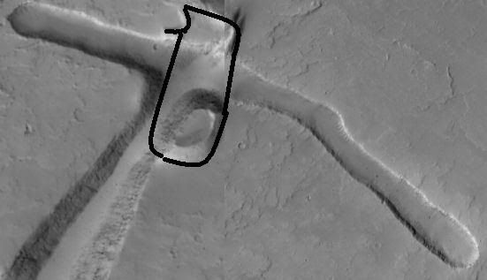
“3- The “base” of the T (uppermost end of T in image) appears to be cut out in the shape of a diamond or oval with flat ledges, giving it a distinctively artificial look.” The “base” of the T-upright which is also the end of the upper arm of the E appeared “diamond shaped” in the early morning glare of the original SP24 T. Now it is clear that a shallow trench (which also appears cleanly cut out) forms a 90° angle with that end of the T-Upright. If one “perfect right angle T” is not likely to form in nature, as Tom suggested in his Slide Show presentation, then two 90° angles forming Ts on both ends of the structure is so much more unlikely to be a natural formation! Referring to crop # 5, there is a round flat-topped mound at this intersection which appears to have been “bisected” or cut across by the T trench at this point, another very natural feature.
“4- The upright part of the T is narrow at the base and widens in an even pattern until it meets the T-cross part, at which point are the two symmetrical inside corners.” The new high resolution image confirms this prediction to a ”T.”
“5- The surface cut of this part of the T is a neat “machine cut” presumably unchanged since its construction due to minimal Martian erosion.” As the reader can see in # 5 and other close-ups, this is still true in the high resolution image, especially when compared to the “more natural appearing” parts of the E, and other similar structures nearby (some of which have been previously posted in this thread).
“6- Dimensions and analysis of shape to follow further reinforce this hypothesis.” The analysis of the dimensions we made in the paper, while beyond the scope of the present post, appears to have been confirmed at least in principle. The T-Upright is over a kilometer in width at its widest part, around 600 feet deep, and with quite uniformly sloped walls and a flat bottom.
I left out one of the most glaring of the artificial aspects of this structure. That is the way the small gully is bisected by the T-Upright trench (see composite # 1 and close-ups # 4 and 9). It seems obvious that the small gully which continues on both sides of the big T trench, was there prior to the construction of the T and was cut across by the T in a way that can only be described as artificial.
Neil
1- The upper part (upright part of T) forms an almost perfect 90° angle to the natural trench.
2- The inner angles are cleanly cut and sloped downward on both sides of the trench with straight walls and a straight surface cut on both sides.
3- The “base” of the T (uppermost end of T in image) appears to be cut out in the shape of a diamond or oval with flat ledges, giving it a distinctively artificial look.
4- The upright part of the T is narrow at the base and widens in an even pattern until it meets the T-cross part, at which point are the two symmetrical inside corners.
5- The surface cut of this part of the T is a neat “machine cut” presumably unchanged since its construction due to minimal Martian erosion.
6- Dimensions and analysis of shape to follow further reinforce this hypothesis. [T or E paper MRB, 6/15/06]
<hr height="1" noshade id="quote"></blockquote id="quote"></font id="quote">
That was written around a year ago. I would now add to "natural meteor gouge-out" above, “exposed lava tube,” or “possible water erosion.” There are several similar formations in the area of the T or E that are most likely natural formations. But I think that the new images add to our confidence that the “T or E” is, at least in part, an artificial structure. We have seen many candidates for artificial structures which appear to have been constructed by using the natural terrain and modifying it in some way. The T or E seems to be no exception. I would like to take the list of predictions I made in the above quote and see how we made out on them. The reader will refer to the croppings above, which I have numbered to coincide with this short analysis.
“1- The upper part (upright part of T) forms an almost perfect 90° angle to the natural trench.” Roughly measuring with a protractor on screen the T still forms a 90° angle with the part of the E-backbone where it intersects (refer to 1, and several of the other crops). The middle arm of the E forms an 80° angle with the E backbone at point of intersection. The bottom arm of the E forms an 88° angle. At this point (given the context) the upper arm (the T) is the most likely artificial in this respect, but the other arms can’t be ruled out. The E backbone is the most likely candidate for the natural structure on which the “strip mine / symbol” was constructed.
“2- The inner angles are cleanly cut and sloped downward on both sides of the trench with straight walls and a straight surface cut on both sides.” When I made this original prediction one could barely see the “inner angles.” Not long before, we and many others still thought that the T was a “mound.” As I recall, I argued for around a week with my brother for the nature and symmetricality of the inner angles before we finally agreed on it. Now that feature is crystal clear. The angles at both ends of the T are much more artificial in appearance than any others seen in the area. The one on the lower right actually forms a “square cut” at ground level (see close-up number 4).
“3- The “base” of the T (uppermost end of T in image) appears to be cut out in the shape of a diamond or oval with flat ledges, giving it a distinctively artificial look.” The “base” of the T-upright which is also the end of the upper arm of the E appeared “diamond shaped” in the early morning glare of the original SP24 T. Now it is clear that a shallow trench (which also appears cleanly cut out) forms a 90° angle with that end of the T-Upright. If one “perfect right angle T” is not likely to form in nature, as Tom suggested in his Slide Show presentation, then two 90° angles forming Ts on both ends of the structure is so much more unlikely to be a natural formation! Referring to crop # 5, there is a round flat-topped mound at this intersection which appears to have been “bisected” or cut across by the T trench at this point, another very natural feature.
“4- The upright part of the T is narrow at the base and widens in an even pattern until it meets the T-cross part, at which point are the two symmetrical inside corners.” The new high resolution image confirms this prediction to a ”T.”
“5- The surface cut of this part of the T is a neat “machine cut” presumably unchanged since its construction due to minimal Martian erosion.” As the reader can see in # 5 and other close-ups, this is still true in the high resolution image, especially when compared to the “more natural appearing” parts of the E, and other similar structures nearby (some of which have been previously posted in this thread).
“6- Dimensions and analysis of shape to follow further reinforce this hypothesis.” The analysis of the dimensions we made in the paper, while beyond the scope of the present post, appears to have been confirmed at least in principle. The T-Upright is over a kilometer in width at its widest part, around 600 feet deep, and with quite uniformly sloped walls and a flat bottom.
I left out one of the most glaring of the artificial aspects of this structure. That is the way the small gully is bisected by the T-Upright trench (see composite # 1 and close-ups # 4 and 9). It seems obvious that the small gully which continues on both sides of the big T trench, was there prior to the construction of the T and was cut across by the T in a way that can only be described as artificial.
Neil
Please Log in or Create an account to join the conversation.
- neilderosa
-
- Offline
- Platinum Member
-
Less
More
- Thank you received: 0
19 years 9 months ago #17484
by neilderosa
Replied by neilderosa on topic Reply from Neil DeRosa
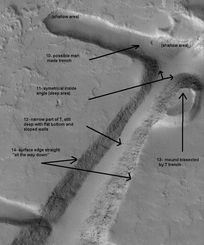
Here are two of the same crops of T labeled for ease of viewing.
Neil
Neil
Please Log in or Create an account to join the conversation.
- neilderosa
-
- Offline
- Platinum Member
-
Less
More
- Thank you received: 0
19 years 9 months ago #9277
by neilderosa
Replied by neilderosa on topic Reply from Neil DeRosa
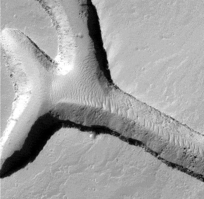
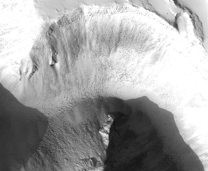
This composite of the narrow end of the "T" is worth adding to the evidence list for a couple of reasons: one is the small flat-top mound bisected by the T trench seems to continue on the other side of the small trench. Another is that it shows both ends of the T trench terminate in roughly 90° angles with symmetrical inside angle walls of fairly consistent slope. My son Tom, who is a BS in geology, says rivers can cut straight through rock outcroppings like this seems to do, but this “dry river bed,” if that’s what it is, begins and terminates only 4 or 5 kilometers in either direction.
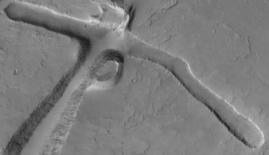
Here's the composite of S1401916 and S2001769, narrow end of T.
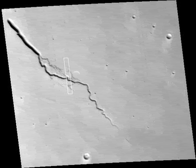
While I'm here, I thought I'd re-post a nearby similar trench for comparison. Here's S0602203 "valley."
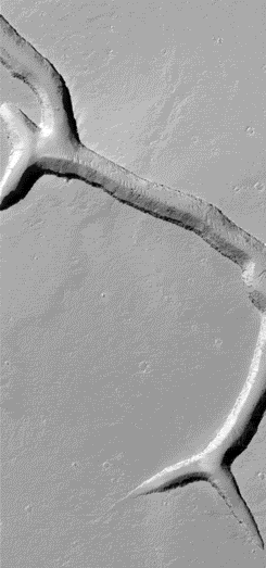
And close up.
Neil
Here's the composite of S1401916 and S2001769, narrow end of T.
While I'm here, I thought I'd re-post a nearby similar trench for comparison. Here's S0602203 "valley."
And close up.
Neil
Please Log in or Create an account to join the conversation.
- neilderosa
-
- Offline
- Platinum Member
-
Less
More
- Thank you received: 0
19 years 9 months ago #9305
by neilderosa
Replied by neilderosa on topic Reply from Neil DeRosa
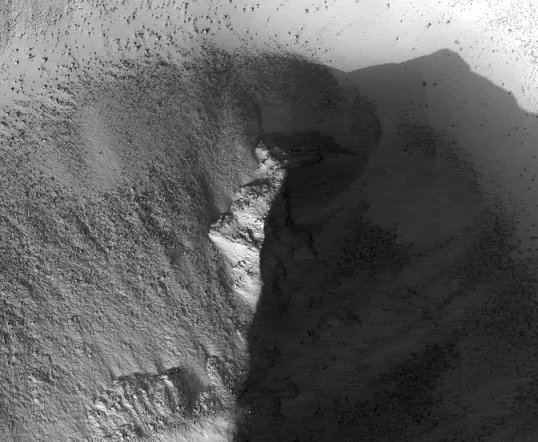
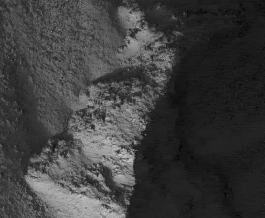
Hypothetical mound before being bisected by excavators. I doubt if we can go any further through b&w imaging or at this resolution
Neil
Neil
Please Log in or Create an account to join the conversation.
- neilderosa
-
- Offline
- Platinum Member
-
Less
More
- Thank you received: 0
18 years 9 months ago #18081
by neilderosa
Replied by neilderosa on topic Reply from Neil DeRosa
This is not exactly an “artificial structures” post, except for the fact that third graders picked out a little scene that has something that resembles a face in it. It’s more about water. The third graders, quoted by NASA in the link, have determined that water made the feature we see here, and the HiRISE and NASA scientists concur. We see similarity with the T or E structure (which is why I resuscitated that thread) in that both are trenches or canyons to the east of one of Mars’ great shield volcanoes. This one is to the east of Elysium Mons; the T or E is to the east Olympia Mons. The “T” looks much more artificial and regular of course, but the “E” part could have been formed by the same process as the feature shown here, called Iberus Vallis—namely by water flow.
But let’s stop and think a minute. Both structures begin and end in flat or gently sloping terrain, and show no apparent source. Both start deep, and end (20-30 km further from the mountain) by tapering off to a shallow trench, as if the water started strong and ended in a trickle, dried up, or sublimated. That can mean one of two things (as I see it): either the source was underground, or a large icy meteor landed and melted on impact. But why so deep a trench (in both cases) from a one-time flood event? On earth, we learn that river bed erosion and canyons take thousands or millions of years to form.
So all we are left with is questions. Neither the third graders nor the NASA scientists give us a satisfactory answer. [Neil DeRosa]
hirise.lpl.arizona.edu/PSP_003637_2020
Iberus Vallis context (MGS MOC R1003970)
Close-ups, (progressive)
Please Log in or Create an account to join the conversation.
Time to create page: 0.252 seconds