
- Thank you received: 0
T or E
20 years 1 month ago #15237
by rderosa
Reply from Richard DeRosa was created by rderosa
Here's the link to the MOC Gallery image for SP243004:
[url] www.msss.com/moc_gallery/ab1_m04/images/SP243004.html [/url]
And here's a context image. This will show you why Neil called this topic "T or E".
Note, this is not an official "context" image, but it's the same location, and the "E" looking feature at the top is in fact the famous "T".
[url] www.msss.com/moc_gallery/m07_m12/images/M07/M0703577.html [/url]
As Neil said, it's very easy to misinterpret this feature and think it's a mound and not a trench, but if you keep in mind that the light is coming from the right, with a little practice you can "lock in" on the proper perspective.
Also, here's a little aid. This first image (left) is taken from the same strip, about a third of the way down. Notice the little triangular area, and the crater. At first glance this can easily look like the triangular area is a trench, and the crater is a ball imbedded in the planet's surface (which is nonsense, of course).
{Image deleted temporarily} T or E/Fig%202.jpg
But, now if you look at the right image (MOC M2201909), which was taken from the same area but at a different time of day and year, you can clearly see that the triangular area is a mound, and the crater is a crater and not a giant tennis ball (dunh!). In this image the light is coming from the left at an angle of 69 deg counter clockwise from the top.
{Image deleted temporarily} T%20or%20E/Fig%203.jpg
Once you get oriented correctly, you can use this feature on SP243004 (left) and follow the trenches up to the "T" to see it as a trench and not a mound.
With a little practice it won't be hard to see that this is what the "T or E" really looks like:
{Image deleted temporarily} T%20or%20E/Fig%204.jpg
And if you're still having trouble, here's a key. This is my rendition of the "miner's view" standing inside the trench, with his back to the top of the T (which is upside down), and looking down the length of the T:
{Image deleted temporarily} Key_crop.jpg
rd
Please Log in or Create an account to join the conversation.
- neilderosa
-
- Offline
- Platinum Member
-

Less
More
- Thank you received: 0
20 years 1 month ago #10755
by neilderosa
Replied by neilderosa on topic Reply from Neil DeRosa
<i>Originally quoted by rderosa</i><blockquote id="quote"><font size="2" face="Verdana, Arial, Helvetica" id="quote">quote:<hr height="1" noshade id="quote">And here's a context image. This will show you why Neil called this topic "T or E".<hr height="1" noshade id="quote"></blockquote id="quote"></font id="quote">

When first looking at this strange looking "mound" my suspicious nature led me to think this was another possible hoax perpetrated by some computer geek at JPL or MSSS, so the first thing I tried to do was to confirm it's existence. SP243004, the hi-res strip that contains the "T" feature, has no "official" context image associated with it. But by taking note of the coordinates of the strip, I found around 10 images which contained the T feature. How did we know it was the same feature seen in the low-res context images? We'll tell you that as we go along.
As you can see from E0300178 posted here, the "T" is not a T at all but more like an "E". The "backbone" of the "E" measures around 18km in length. Off to the left is the escarpment to Olympus Mons, the highest mountain in the solar system.
Neil
Please Log in or Create an account to join the conversation.
20 years 1 month ago #10756
by rderosa
Replied by rderosa on topic Reply from Richard DeRosa
<blockquote id="quote"><font size="2" face="Verdana, Arial, Helvetica" id="quote">quote:<hr height="1" noshade id="quote"><i>Originally posted by neilderosa</i>
<br />Off to the left is the escarpment to Olympus Mons, the highest mountain in the solar system.
<hr height="1" noshade id="quote"></blockquote id="quote"></font id="quote">
That's a mind-blowing concept: "the highest mountain in the solar system." I just saw that somewhere recently, and thought, "you're kidding, what are the odds of that?"
That opens all kinds of possibilities: recreation, power generation, mining (there's gold-and silver-in them thar hills), etc.
rd
Please Log in or Create an account to join the conversation.
- neilderosa
-
- Offline
- Platinum Member
-
Less
More
- Thank you received: 0
20 years 1 month ago #10785
by neilderosa
Replied by neilderosa on topic Reply from Neil DeRosa
Ironically, Rich was more convinced of the artificiality of the T feature than I was (my confidence level on this one is around 80%...75-80%). One of the reasons was that we found other gullies nearby, at the foot of the escarpment to Olympus Mons actually, in MSSS strip #M0303753. These gullies had two characteristics of the T or E feature: they had "T" shaped tributaries branching off of them, and they had sloped walls and flat bottoms similar to the T feature. But they lacked other characteristics found in the T or E feature.
I thought the gullies might have been caused by running water, or even lava flows, sometime in Mars's past. Rich thought they might have been originally such gullies, but were subsequently modified by mining operations that would explain the adjoining T-shaped tributaries, sloped walls, and flat bottoms. (Note that because of the psychological light inversion effect, [LIE], these gullies often also look like wierd mounds, and that it takes training and self discipline to see them as they actually are--as gullies.)
Neil
Please Log in or Create an account to join the conversation.
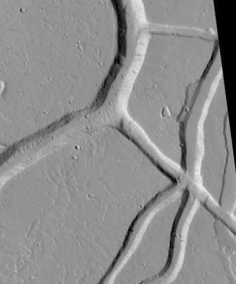
20 years 1 month ago #10786
by rderosa
Replied by rderosa on topic Reply from Richard DeRosa
<blockquote id="quote"><font size="2" face="Verdana, Arial, Helvetica" id="quote">quote:<hr height="1" noshade id="quote"><i>Originally posted by neilderosa</i>
<br />I thought the gullies might have been caused by running water, or even lava flows, sometime in Mars's past. <hr height="1" noshade id="quote"></blockquote id="quote"></font id="quote">
Here's the link to MOC# M0303753:
[url] www.msss.com/moc_gallery/ab1_m04/images/M0303753.html [/url]
If you look at the top of the strip, you can see that the main tributary appears to start at the base of the mountain, although I suppose it is possible that the elevation at the "source" is still significantly higher than it is further down where all the crossroads are.
But, if it was some kind of "river" at one time, than why are the areas near the single arrows on the right of Fig. 2 still filled in? I can't imagine some type of flow ending like that. Did they fill in at a later date? That seems unlikely for a couple of reasons. One being they appear to have the same distribution of cratering as at the bottom of the open trenches.
Fig. 1:
{Image deleted temporarily} T or E/Fig%209.jpg
Fig. 2:
{Image deleted temporarily} T or E/M0303753_CROP4_150pct.JPG
Also, as Neil suggested, take a look at the cross roads marked by the double arrows. Why are they much shallower than to two vertical tributaries? You see that type of thing on farms all the time, where there are two main areas being harvested, and the farmer has to move back and forth where the workers are, without going "all the way around". A bit fanciful? Maybe, but perhaps they were the connecting roads between the two main veins, and the still "filled in" tributaries are unmined veins.
There's one easy way to find out, or at the least get some corroborating evidence, and that is to find out what's in the walls of those open trenches.
rd
Please Log in or Create an account to join the conversation.
20 years 1 month ago #10787
by Trinket

Every Image ever released has gone thru the JPL Image muting and distortion process..
God created the Internet in 6 days and on the seventh day he ... beta tested
Replied by Trinket on topic Reply from Bob
Every Image ever released has gone thru the JPL Image muting and distortion process..
God created the Internet in 6 days and on the seventh day he ... beta tested
Please Log in or Create an account to join the conversation.
Time to create page: 0.271 seconds