
- Thank you received: 0
Mro--First Looks
19 years 8 months ago #17533
by rderosa
Replied by rderosa on topic Reply from Richard DeRosa
<blockquote id="quote"><font size="2" face="Verdana, Arial, Helvetica" id="quote">quote:<hr height="1" noshade id="quote"><i>Originally posted by neilderosa</i>
<br />I just downloaded and did preliminary surveys of two images. "Ius Chasma," and "Condor Chasma." <hr height="1" noshade id="quote"></blockquote id="quote"></font id="quote"> The Candor Chasma image should be pretty close to Skully, but not quite close enough. AB1-08403 centers at 75.19°W, 5.04°S and the new one at 75.4W, 5.70S. The 0.7 diffence is pretty big.
Here's a good definition of "binning" and how it reduces noise at the cost of resolution.
www.noao.edu/outreach/aop/glossary/binning.html
rd
Please Log in or Create an account to join the conversation.
19 years 8 months ago #17534
by rderosa
Replied by rderosa on topic Reply from Richard DeRosa
Here's a quote from one of the HiRISE images:
"At this distance the image scale is 26 cm/pixel (with 1 x 1 binning) so objects ~78 cm across are resolved."
Apparently, they're saying that it takes 3 pixels to resolve something. If we want to measure something, and we put that into perspective with the 10% Rule for Measurement Tools, we would need 10 pixels to measure at an accuracy of 1 pixel.
That would mean, at this resolution we could measure something that was 8.5 feet in size accurately and repeatably to about 10 inches. That's something roughly the size of a living room couch, accurate to 10 inches.
rd
Please Log in or Create an account to join the conversation.
- neilderosa
-
- Offline
- Platinum Member
-

Less
More
- Thank you received: 0
19 years 8 months ago #17536
by neilderosa
Replied by neilderosa on topic Reply from Neil DeRosa
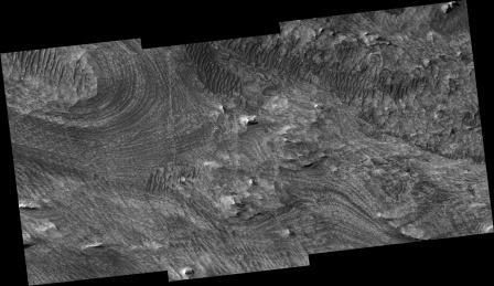
Here's the result of my first look at the new HIRISE images. All posted images are compressed:
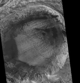
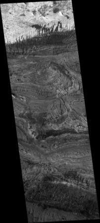
TRA000836 Condor Chasma (at around 2 percent magnification). Actually the name is quite misleading because the image is not much bigger than an "old style" HR swath from the MOC. IMO what they should have done is to follow the catalogue system (or at least refer to it) of the MSSS gallery. This is really only one very small, miniscule part of Candor Chasma. The image is 22172 pixels wide x 25 cm / 100 = 5543 meters wide = 5.543 km wide, and around 3 km high.
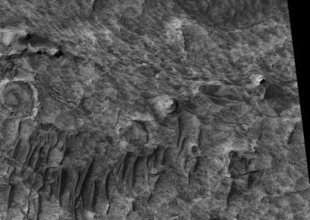
TRA sample crops.
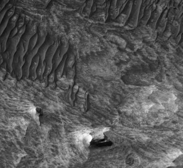
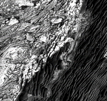
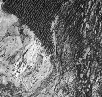
And here are some MOC images from the same area. I was not able to match the exact location though I should have been able to, but the TRA image was so vague. The MOC images are better all around.
M1103947 sample.
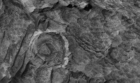
R1101204 sample.
R1701827 samples.
This image was as close to the HIRISE center I could find.
TRA000836 Condor Chasma (at around 2 percent magnification). Actually the name is quite misleading because the image is not much bigger than an "old style" HR swath from the MOC. IMO what they should have done is to follow the catalogue system (or at least refer to it) of the MSSS gallery. This is really only one very small, miniscule part of Candor Chasma. The image is 22172 pixels wide x 25 cm / 100 = 5543 meters wide = 5.543 km wide, and around 3 km high.
TRA sample crops.
And here are some MOC images from the same area. I was not able to match the exact location though I should have been able to, but the TRA image was so vague. The MOC images are better all around.
M1103947 sample.
R1101204 sample.
R1701827 samples.
This image was as close to the HIRISE center I could find.
Please Log in or Create an account to join the conversation.
19 years 8 months ago #17537
by rderosa
Replied by rderosa on topic Reply from Richard DeRosa
<blockquote id="quote"><font size="2" face="Verdana, Arial, Helvetica" id="quote">quote:<hr height="1" noshade id="quote"><i>Originally posted by neilderosa</i>
<br /> This is really only one very small, miniscule part of Candor Chasma. The image is 22172 pixels wide x 25 cm / 100 = 5543 meters wide = 5.543 km wide, and around 3 km high.<hr height="1" noshade id="quote"></blockquote id="quote"></font id="quote">Yes, if you think about it, it stands to reason that the higher the magnification, the smaller the image. At least that's true for any given microscope.
There's nothing to say they <b>couldn't </b>do both (higher mag and bigger surface area), but I would think the amount of data to be transferred back would start to get cumbersome.
If you've ever attempted to scan an image at the highest resolution available in the software, you get an error message saying the image would take up more space then the entire available space on the harddrive.
rd
Please Log in or Create an account to join the conversation.
19 years 8 months ago #17538
by rderosa
Replied by rderosa on topic Reply from Richard DeRosa
I think this might put it into perspective. Here's a direct comparison of an area 163 square meters in size.
NOTE: All of these images are exactly to scale.
First from a familiar feature, the crack in the east side Face. 100 square pixels by 1.63m/p:

And now from TRA_000836_1740. 627 square pixels by 0.26m/p:

I added a box to show a 100x100 pixel square on the new image, plus a box on the top image shows an equivalent size area of approximately 26 square meters, or roughly the size of small property in suburbia.
Here's the crack blown up 626% to theoretically match the magnification of the TRA image. Note the empty pixels.

So, if we extrapolate what the first image might look like at 26cm/p, I would guess we might see into the crack a little ways. Maybe to the bottom of it, if it's not totally black.
To finalize the demonstration, this is what it might look like if there were houses there (and color pics). If you imagine trying to fit two houses in the tiny box in the top image of the crack, you can readily see what a drastic improvement this is.

rd
NOTE: All of these images are exactly to scale.
First from a familiar feature, the crack in the east side Face. 100 square pixels by 1.63m/p:
And now from TRA_000836_1740. 627 square pixels by 0.26m/p:
I added a box to show a 100x100 pixel square on the new image, plus a box on the top image shows an equivalent size area of approximately 26 square meters, or roughly the size of small property in suburbia.
Here's the crack blown up 626% to theoretically match the magnification of the TRA image. Note the empty pixels.
So, if we extrapolate what the first image might look like at 26cm/p, I would guess we might see into the crack a little ways. Maybe to the bottom of it, if it's not totally black.
To finalize the demonstration, this is what it might look like if there were houses there (and color pics). If you imagine trying to fit two houses in the tiny box in the top image of the crack, you can readily see what a drastic improvement this is.
rd
Please Log in or Create an account to join the conversation.
- neilderosa
-
- Offline
- Platinum Member
-
Less
More
- Thank you received: 0
19 years 8 months ago #17539
by neilderosa
Replied by neilderosa on topic Reply from Neil DeRosa
<blockquote id="quote"><font size="2" face="Verdana, Arial, Helvetica" id="quote">quote:<hr height="1" noshade id="quote">And here are some MOC images from the same area. I was not able to match the exact location though I should have been able to, but the TRA image was so vague. The MOC images are better all around.
[see pics above to go with this caption]<hr height="1" noshade id="quote"></blockquote id="quote"></font id="quote">
Thanks for the explanation as to what the higher resolution would imply in theory. That should have been obvious but may not have been. But naming a small local image after the whole geographic region could be misleading to a novice. But my point had to do more with the quality (so far) and the bugs in this particular image. Although I didn't quantify it, if you look at the black squiggly features (don't know what they are) in both the MOC and the HIRISE images, what I tried to do was to make them the same size so the viewer could compare the quality between the two. Theoretically, the HIR image should have been 6 times better resolution, and it may have, in places. But if you look at the terrain between the black squigglies, in the MOC images you can see detail, in the HIR image you can not. Also, in lower magnifications of the HIR image, sharpness has been seriously compromised, as if it were still a work in progress. Whereas the MOC images are clear at both high and low magnification up and until pixel breakdown. I was commenting on the quality of the particular, not the theory. Though I ran out of time to post more examples, and I’ll let this drop because this is a side issue.
Please Log in or Create an account to join the conversation.
Time to create page: 0.466 seconds